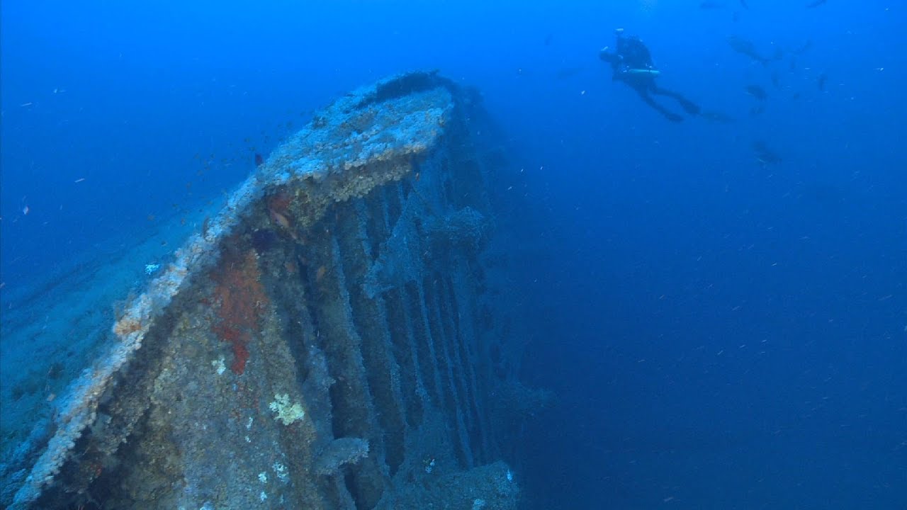
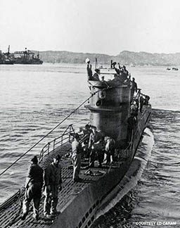
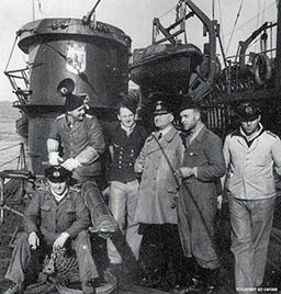
It was the spring of 1942, and the world was at war. German U-boats prowled throughout the Atlantic Ocean, hunting and sinking merchant vessels bound for Allied ports in Europe, the Mediterranean and North Africa. Months earlier, as America’s entry into the Second World War officially ended U.S. neutrality, U-boats eagerly entered American waters. Here, merchant shipping traversed the length of the Eastern Seaboard unprotected. Within eight months U-boats had attacked nearly 285 merchant ships. U-boat commanders referred to these months as “a happy time” in their war diaries. Although the U.S. Navy was slow to mobilize after Pearl Harbor, it learned from these early defeats and by the spring was beginning to fight back.
In April, American warships sank U-85 and then in the weeks that followed, U-352, U-157, U-215 and, in early July, U-701. More and more, patrol ships and aircraft pursued U-boats making sorties into American waters, hindering their ability to attack merchant ships. By midsummer the battle between German U-boats and the American Navy was coming to a head. The U-boats persisted, however, and merchant casualties continued to mount.
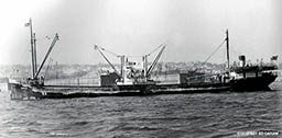
It was a blustery July afternoon off Cape Hatteras, N.C., when U-576 maneuvered into an attack position ahead of a slow-moving group of 19 merchant ships. Forced to travel at the speed of the slowest ship, the convoy steamed along at 8 knots, virtually sitting ducks for the sleek U-boat. Unlike the earlier months of 1942, however, when several U-boats would have been able to attack these ships uncontested, five destroyers and cutters from a joint Navy and Coast Guard escort group now guarded the convoy’s perimeter. One thousand feet above, U.S. Navy aircraft kept a vigilant watch, circling the convoy and searching for the telltale sign of lurking submarines: a distinctive periscope wake. The “happy time” of early 1942 was over; U-576 now faced a formidable force.
A stiff wind blew all morning, and white-capped waves allowed U-576 to approach to within a few kilometers of the convoy undetected. At around 4:15 p.m., four torpedoes slammed into the convoy, hitting three ships. One of the ships, the Nicaraguan freighter Bluefields, began sinking rapidly. Chaos ensued as the other 16 merchant vessel scattered in all directions.
Then the unexpected happened: U-576 surfaced. Without hesitation, the armed merchant vessel Unicoi poured gunfire onto the U-boat. Simultaneously the patrol aircraft dive-bombed the submarine, and within minutes U-576 was going down with all hands on board. The damage had been done, however: Bluefields sank just minutes later, and the two other stricken vessels were barely afloat. Slowly, rescue operations reestablished order, and convoy KS-520 resumed its southerly course, less three ships. Neither Bluefields nor U-576 was ever seen again.
While Bluefields was the only vessel to immediately sink, more damage was yet to come. Two men aboard the first ship hit, tanker J.A. Mowinckel, died in the initial blast. Later, a tugboat was lost to friendly mines during the rescue operation, and the third ship hit, Chilore, sank while under tow to Norfolk, Va., for repairs.
Review of postwar records revealed why, after a textbook attack, U-576 surfaced. The morning prior, a different group of Navy patrol aircraft had spotted and surprise-attacked the submarine. Although it was able to dive and escape total loss, the U-boat sustained irreparable damage. Instead of retreating, however, the submarine’s captain decided to take his wounded boat into battle, a fateful decision that resulted in his crippled vessel surfacing within range of Unicoi‘s guns and into a hail of aerial depth charges.
The sinking of U-576 signaled the end of major German attacks off the U.S. East Coast. Up and down the Eastern Seaboard the U.S. Navy and Coast Guard were aggressively attacking U-boats. No longer able to sustain their campaign, the U-boats withdrew. In the ensuing decades, many casualties of this battle were rediscovered; they are now the quintessential shipwrecks of North Carolina, monuments to past conflict, sacrifice and duty. However, the remnants of this signal battle, the turning point off the N.C. coast, were never found. Instead the final resting place of Bluefields and U-576 became another mystery of the Graveyard of the Atlantic.
A Legacy That Inspired Exploration and Research
Like many wrecks off North Carolina, these ships were lost but not forgotten. The Second World War occupied a place of fascination among the state’s historians, whose work shed light on this little-known aspect of America’s past. Historians, archaeologists, divers and enthusiasts studied and expanded upon their foundational work and, in so doing, were able to locate many of the state’s lost shipwrecks.
In 2007, in response to reports of damage to the wrecks of other U-boats sunk in the region, the Office of National Marine Sanctuaries of the National Oceanic and Atmospheric Administration (NOAA) took action. They assembled a collaborative research team composed of scientists from East Carolina University (ECU), the Coastal Studies Institute at the University of North Carolina (UNC) and the U.S. Bureau of Ocean Energy Management (BOEM) to document and assess U-boat wrecks off North Carolina. This partnership grew into a comprehensive research effort to archaeologically survey numerous World War II shipwrecks in the region and expanded to include support from the National Parks Service (NPS) Submerged Resources Center, NOAA’s Office of Exploration and Research and UNC-Wilmington.
Through this network the team was also able to access leaders in oceanographic technology such as Woods Hole Oceanographic Institution, the Applied Research Lab at the University of Texas (ARL:UT), SRI International, ADUS DeepOcean and Cardinal Point Captains. The resources and technology from this collaborative team, along with its growing database of information, allowed researchers to shift some of their focus from documenting known shipwreck sites to searching for those still missing. At the top of this list were Bluefields and U-576.
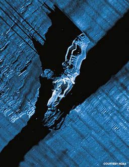
Meanwhile, NOAA-led expeditions were becoming a springboard for academic studies within ECU’s Program in Maritime Studies. Specifically, Nathan Richards, Ph.D., and Tom Allen, Ph.D., began considering innovative ways to digitally reconstruct naval battlefields, an approach that allows researchers to see the landscape as the combatants saw it and, therefore, better understand these naval engagements. A pilot study was led by graduate student John Wagner, who reconstructed the entire WWII theater off North Carolina. A review of Wagner’s work indicated that the U-576 attack would be an ideal case study to further focus and develop this methodology. To this end, ECU with support from NOAA’s Monitor National Marine Sanctuary, secured a grant from the NPS’s American Battlefield Protection Program. This grant along with additional NOAA and BOEM support enabled ECU graduate student John Bright to pursue an archaeological battlefield survey of U-576‘s convoy attack for his master’s thesis.
Using a multitude of archival documents, Bright and fellow ECU student Stephen Sanchagrin created a digital 3-D model of U-576‘s attack. Next, Bright plotted coordinates from ships’ logs along with attack positions given in after-action reports. He also integrated seafloor maps and historical weather data. The numerous historical sources gave the researchers hope that these coordinates would lead the team to the specific spot of the attack. Unfortunately, precision location technology did not exist in 1942, and the various reports gave positions that were scattered over hundreds of square miles, leaving only a vague idea of the battle’s exact location.
Knowing where the battle took place, however, was essential for completing the battlefield survey. Thus, they analyzed period naval tactics, weapons technology and written accounts to predict a series of possible locations. This ultimately allowed Bright to complete his academic battlefield study and formed the basis of a NOAA-led effort to locate the remains of Bluefields and U-576.
The Search Begins
During the summer of 2011 NOAA archaeologist Joe Hoyt orchestrated the first hunt for U-576 and Bluefields. In close collaboration with Richards and Bright, Hoyt arranged for the use of a one-of-kind autonomous underwater vehicle (AUV) equipped with a specialized sonar array developed by ARL:UT. This device allowed the team to scan the ocean floor, looking for the signs of sunken ships. Each pass revealed a kilometer-wide strip and, like mowing the lawn, overlapped the adjacent scans.
Hour by hour and day by day these scans added up to an increasingly large map of the seafloor. Yet, the survey encountered an insurmountable factor that confounded the entire mission: surging Gulf Stream currents. At depths beyond 500 feet these currents were so great that the AUV could not operate properly. Thus limited to shallow water, the team was unable to scan the deeper portions of the area where U-576 and Bluefields were thought to rest. Nevertheless, the AUV had already detected nearly 50 sonar anomalies — objects that could be shipwrecks. Each one would have to be individually investigated to determine if it was indeed a sunken vessel; the team members had quite a job ahead of them.
With an incomplete survey and many targets needing additional investigation, the results of the 2011 mission were inconclusive. Undaunted, the team spent 2012 evaluating the 50 sonar anomalies. While none turned out to be U-576 or Bluefields, these investigations resulted in several new shipwreck discoveries. Concurrently, the research team also sought opportunities to collect more sonar data inside the unexplored deep sections of the search area. This led the team to low-resolution images in NOAA’s archive that had been produced as part of the administration’s mission to generate large seafloor maps. The team also requested new surveys to be conducted by NOAA’s large fleet of oceanographic research vessels when they travelled through the area.
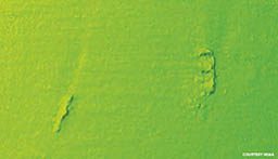
While reprocessing NOAA surveys to plan upcoming AUV dives, SRI made a critical discovery — a narrow ridge, approximately 250 feet long, along the otherwise flat bottom. It could have been a rock or a faint acoustic return from a sunken ship in deep water. Armed with this new clue, the team narrowed its search to this area; by spring 2013, NOAA arranged another survey effort. If this anomaly turned out to be Bluefields, the U-576 would not be far away.
Unlike in previous years when the team utilized an advanced AUV, that year it had only a small, towed sonar system. Though narrow, single images could be gathered, the extreme current and water depth prohibited a wider survey. Nevertheless, the research team pushed this sonar system to its limit with astonishing results. Vessel captain Pasquale DeRosa lined up three near-perfect passes over the target, and the sonar captured an image of a shipwreck that was an exact match to Bluefields. Half of the puzzle, it seemed, was solved.
NOAA’s Office of Ocean Exploration and Research coordinated with the research team and arranged for the NOAA ship Okeanos Explorer to run its cutting-edge sonar within an updated search grid as it passed. The research team eagerly awaited the sonar scans, and when the ship’s surveyor reported back, the findings left the team speechless. Within the sonar image were two distinct objects: One was the target previously identified as Bluefields, and a short distance away was a cylindrical object the exact dimensions of a Type VII-C German U-boat. It was the oceanographic equivalent of a smoking gun.
The Final Push
This image, however, was not definitive enough to remove all doubt that the object was actually U-576. More information was needed, and a final push was arranged for late summer 2014. The methodology for the return trip was straightforward. NOAA invited SRI to return with an AUV geared specifically for targeted deep-water survey. True to form, however, the Graveyard of the Atlantic would not give up its secrets easily. Logistical, mechanical and weather difficulties (including a hurricane) dogged the team. When the expedition finally got under way, only a few days remained in the schedule.
After two days of calibration dives the AUV was ready to scan the target identified by the Okeanos Explorer. The anticipation was palpable as the team members made their final adjustments and, on day three, the AUV completed its first mission over the target. As soon as the vehicle was back aboard, the team downloaded its information. Everyone present hovered around the science lab as the data files were opened. Within them, a shape emerged.
The sonar data was converted into a 3-D point cloud. Individual sonar pings arranged themselves into a composite image: the unmistakable lines of a German U-boat. A riotous exuberance broke out in the form of smiles, laughter, handshakes, hugs and even a few tears. Finally, after six years of research and survey, both Bluefields and U-576 had been found.
Over the course of those years, which comprised archival study, digital modeling and oceanographic survey, the puzzle of convoy KS-520’s battle location was solved. Without a collaborative team of dozens of people sharing information, technology, resources, expertise, time, advice and energy, these sites would remain unknown to us. It was in this collegial spirit of research that mysteries of the past were unlocked, the memory of those who served was honored and another special place — a memorial to those lost and a timeless monument to duty, sacrifice and service — was discovered.
Explore More
© Alert Diver — Q1 Winter 2015
