Exploring the Pacific Remote Islands Marine National Monument
Humans are perhaps the greatest threat facing our oceans. Overfishing, sewage runoff and sunscreen pollution are just a few of the localized impacts we have inflicted throughout our turbulent history with the ocean. Despite the harmful effects of many people, the positive impacts of scuba divers are a refreshing beacon of optimism. We are some of the most vocal ambassadors for a cleaner, healthier, more diverse aquatic habitat, yet our scuba bubbles can scare fish, and we risk introducing invasive species from one dive spot to another.
Recognizing that aquatic wildlife need some respite, resource managers work to preserve and protect areas for wildlife to thrive without human interference. Biologists occasionally check on these protected tracts of ocean to ensure they are left untouched to flourish on their own. I recently had the opportunity to visit one of these special places: the Pacific Remote Islands Marine National Monument (PRIMNM).
Originally stopover points for Polynesian voyaging canoes, these seven tiny islands and atolls in the Central Pacific provided resources for whalers and were a valuable source of guano (seabird excrement) for fertilizer in the mid-19th century, leading the United States to claim the area under the Guano Act of 1856. During World War II the U.S. military had strategic bases on the islands.
First established on Jan. 6, 2009, the PRIMNM was expanded from 83,000 square miles to approximately 490,000 square miles of the Pacific Ocean on Sept. 25, 2014, becoming the largest marine protected area in the world. These islands are home to 14 million seabirds from 19 species and a black coral species (Leiopathes sp.) that lives more than 4,200 years. While many divers covet the reefs of the nearby Papahānaumokuākea Marine National Monument northwest of the main Hawaiian Islands, fish biomass in the PRIMNM is 10 times greater than at inhabited, heavily impacted main Hawaiian Islands and twice that found in the northwestern Hawaiian Islands.
Scientists with the National Oceanic and Atmospheric Administration (NOAA) and the U.S. Fish and Wildlife Service visit the area every three years to survey the marine ecosystems, swap out monitoring equipment and assess the few on-land structures. On this trip we visited five of the seven islands and atolls that make up the PRIMNM: Howland, Baker and Jarvis Islands, Palmyra Atoll and Kingman Reef. We also visited Swains Island, a remote outpost of Samoa.
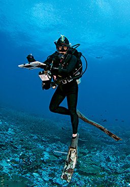
I was assigned to help the fish assessment team; most of our team’s seven members had advanced degrees in some discipline of marine biology. We worked with a team that studied coral health and one that studied ocean climate change. Together, the teams’ data show us how these islands are changing over time without localized human impact, and their remoteness makes them a global indicator for ocean health. They may be “out of sight, out of mind,” but each island was uniquely impressive, and it was a treat to see such untouched environments.
For eight days on a ship slowly plowing southwest from Honolulu, Hawaii, we worked on preparations, neurological exams, station tours, gear assignments, methodology refinements and fish-ID tests. I had been issued a camera, a data slate, a safety sausage and a personal locator beacon. Cell phone service ran out sometime in the morning on day one, and by day four the excitement of our pending expedition was starting to wear thin. Finally we saw land: a mile-long spit of sand called Howland Island.
Howland and Baker Islands
Howland and Baker are the kinds of islands that castaways dread, without trees, fresh water or resources useful for survival. There are, however, thousands of seabirds and even more hermit crabs. Of the two islands, Howland is better known because it was Amelia Earhart’s intended destination before she disappeared. Even if we were allowed to go ashore, few of us had the desire. Beneath the waves it was an entirely different story. After we studied for months to memorize 900 fish species and their four-letter codes, Howland and Baker were our first tests.
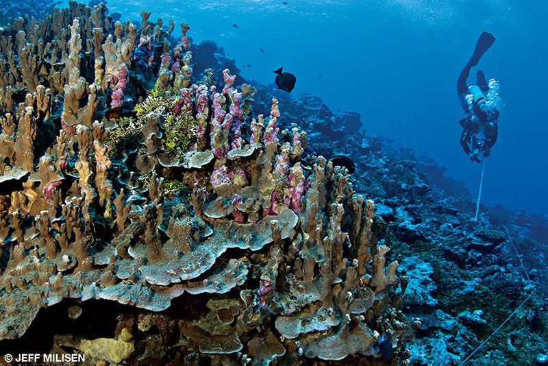
Hard corals grow from every available surface down the steep slope of the islands. Thousands of fish form clouds so thick that they often occlude visibility. It was spectacular yet daunting because we had to try to count everything, and the fish clouds were composed of multiple species and frequently changed. We spent the first five minutes of our survey identifying and listing the species that were present; we spent the rest of the dive counting and sizing individuals in each species.
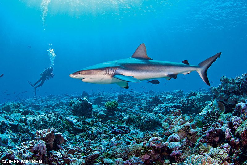
Our fish-counting team was using methods that were new to many of us, and the visual cacophony of these vibrant marine communities could be rather distracting. Unlike other areas, the east side of Baker Island forms a plateau, allowing fields of staghorn corals to reach their maximum proportions. The fish clouds here were especially thick. My buddy, Jake, swam out a transect line and disappeared into the swirl of fishes as I placed the transect reel down in front of a dragon moray (Enchelycore pardalis) slinking back into its lair. A few gray reef sharks (Carcharhinus amblyrhynchos) wove their way through a thick school of black jacks (Caranx lugubris).
Jake swam back along the transect to check the visibility, but I could tell by the look on his face that he was as baffled as I was by the volume of life surrounding us. This lasted the entire dive, with school after school of predatory fish moving in visual symphonic harmony. We reluctantly ascended after an hour and climbed on board, stunned at what we had just experienced. Still, my coworkers were adamant that Howland and Baker would turn into a distant memory as soon as I witnessed the impressive bounty of life that Jarvis would offer.
Jarvis Island
In years past I was told that Jarvis Island was the wildest in the PRIMNM. The most curious sharks, lushest reefs, biggest mantas and most graceful schools of hammerheads greeted previous expeditions. Climate change, however, has warmed the waters around the island, and in 2015 an El Niño event brought even warmer water to the island’s coast. The temperature increase also prevented upwelling, essentially cutting off the flow of nutrients into the ecosystem and the island’s “air conditioner.” This doubly shocked the corals around Jarvis, and many of them fell victim to bleaching. As a result, 98 percent of the lush coral at Jarvis died in 2015–16.
Swimming around Jarvis three years after such a massive bleaching event was surreal. Much of the reef structure was still intact, even if it was composed of dead corals, and clouds of planktivorous fishes were still feeding off the oceanic currents. Even the mantas and many of the sharks were still there, but we counted very few corallivores such as butterflyfish because the coral suffered near-complete mortality. Almost everything was still in its place, but it was over fields of coral skeletons rather than colorful hard bottom. If this reef ecosystem continues to collapse over the next few years, it will be interesting to see if the remaining animals can adapt. In the face of a warming planet, Jarvis is an all-too-real reminder of the grim future for coral reefs.
Kingman Reef
Kingman Reef is a mostly submerged, triangular, shallow area that spans almost 10 miles latitudinally and 5 miles longitudinally. Parts of the reef above the surface appear as tiny areas of land amounting to three small sand spits. These three tiny beaches mark one of the most diverse habitats in U.S. waters. Huge mounding coral structures fortify the southern reef’s edge, the protected western slope consists of mostly solid branching coral, and the interior lagoon floor is carpeted in soft corals. The scenery changes drastically everywhere you go on Kingman, and predators typically stand guard over every inch of it. When dawn broke the morning of our arrival, however, all we saw were waves breaking over the shallow reef.
Beneath those breaking waves is something truly special. Along the south shore is an area called Giant Clam Gardens, which has the highest density of giant clams observed anywhere in the Pacific Islands region. Two species of giant clams have taken over to create the only Central Pacific reef that is comprised largely of giant clamshells. The bivalves cluster and grow on top of one another to create structures like those of coral reefs.
Diversity can act as insulation against marine ills, and this is most evident on Kingman. We observed some algal overgrowth and the presence of a few crown-of-thorns starfish, but each impact at Kingman was isolated to one area. Some of the massive coral structures along the southern shore, for example, had become overgrown by Halimeda algae, which is a native species and usually not a threat to coral. For some reason, however, a Halimeda bloom appeared in isolated areas, while everywhere else was untouched. Other areas rich in delicate coral suffered bleaching from the 2015 event, but recovery of more hardy species had begun at Kingman, unlike at Jarvis. This ocean environment is constantly changing, and the trend we observed indicates that maintaining a high level of diversity may be one of the keys to surviving climate change.
Palmyra Atoll
Before I was even a twinkle in my parents’ eyes, they bought a camera, loaded a sailboat and set course for a remote island called Palmyra. As its name might suggest, Palmyra is home to many palm trees, seabirds and a dense population of four different species of land crabs, including the quintessential coconut crab. At the time of my parents’ visit, it was also home to a guy named Hal, who was part of a group who had made a deal with the Nature Conservancy to keep the runway clear in exchange for permission to live on the island. When his group first arrived at Palmyra, they realized they had forgotten some essential tools. They left Hal alone on the island while they went back to Honolulu to resupply and never returned for him.
Hal kept some shred of sanity through his amateur radio, which was powered by a diesel generator. When his Meal, Ready-to-Eat (MRE) rations ran out, he planned to eat fish and coconut crabs. My parents showed up six months after he was deserted, but the then slightly feral Hal opted to stay on his personal island rather than join the rest of civilization.
My parents passed along stories to their offspring, providing vivid descriptions of this oceanic paradise and painting early visions of a tropical utopia in the imaginations of children who had scarcely even seen palm trees. Decades later, one of their children visited this insular inspiration.
Palmyra Atoll is roughly 4 miles long and has two lagoons, one of which is a safe harbor area known as West Lagoon. Its shallow reefs extend an additional 5 miles to the west and 2 miles to the east. Reef manta rays and adorable blacktip reef sharks are abundant in the shallow areas. Hard corals completely surround the island, but the Coral Gardens site is especially breathtaking. Various species grow on top of each other to form majestic, vertical columns of living coral that sprout from the seafloor 20 feet below and emerge from the surface. But my most intense memories of Palmyra came from the deeper, westward slope.
At the fringes of the western slope, the currents that nurture the lively reef also bring a suite of predators that make diving here especially electric. On one dive we descended into a school of more than 50 baby gray reef sharks. Meanwhile, a few humphead wrasses danced with the current in the distance. Blacktips cruised by with such regularity that I lost count of them. A couple of bruiser adult gray reef sharks came by mid-survey to remind us who really owns this place. The surveys were the priority, but sometimes the displays of nature in these remote areas require the observer to take a moment to enjoy how special these islands are.
Hal caught a ride back long ago, but after seeing this island with my own eyes I understand his reluctance to leave. Palmyra, much like the other remote islands, is an area that we should be proud to protect. The United States is full of wild lands, but the islands that make up the PRIMNM stand out because no one has ever attempted to tame them. Peter T. Young, who helped form the foundation for the PRIMNM, once said that stringent protective measures are “the responsibility we share to provide future generations a chance to see what it looks like in a place in the world where you don’t take something.” Keeping these islands and the reefs that surround them pristine and untouched is one of the most effective ways to fulfill this responsibility.
Explore More
Learn more about NOAA’s expedition to the Pacific Remote Islands in these videos and on NOAA’s website.
© Alert Diver — Q2 2019