The battle lasted a mere 13 minutes. One hundred and fifty years ago and 20 miles off the coast of Galveston, Texas, two ships exchanged punishing broadsides from 100 yards apart. At 7 p.m. on Jan. 11, 1863, 11 days after the Confederates recaptured the port of Galveston, the CSS Alabama under the command of Capt. Raphael Semmes outmaneuvered and outgunned Capt. Homer Blake’s armor-plated USS Hatteras and sent it bow first to the bottom, where it rests today in 57 feet of water. The Union survivors, including Capt. Blake, were imprisoned in Port Royal, Jamaica. When the USS Brooklyn arrived at the scene the following morning, the Hatteras was resting upright on the bottom with both masts sticking out of the water and its Navy flag swaying in the light breeze.
A former merchant ship, the Hatteras was outfitted with guns and iron plating at the Philadelphia Navy Yard. It is the only U.S. warship sunk in battle in the Gulf of Mexico during the Civil War. The historical significance of the Hatteras wreck is enormous because of the speed at which it sank, its depth and its cargo of guns, ammunition, personal effects and even the ship’s cash box. The wreck remains largely intact and untouched.
In 1976 Rice University professor Paul Cloutier rediscovered the wreck while field-testing a recently designed magnetometer. Like a submerged time capsule, the wreck lay mostly buried in the sand-and-silt bottom. Portions of the two paddle wheels, the stern post, parts of the steam engine and the walking beam drive mechanism were all that protruded from the seafloor. Two years later Cloutier took the U.S. Navy to court to obtain admiralty rights; he was unsuccessful, and the Hatteras remains the property of the U.S. Navy. For the next three decades few divers — mostly state, federal and contract archeologists — dived on the Hatteras.
Visibility in the area is highly variable, ranging from zero to 40 feet. After Hurricane Ike (2008) and other turbulent weather passed directly over the wreck, divers conducting surveys for the Bureau of Ocean Energy Management in 2010 reported that a significant amount of cover had been swept away, exposing more of the wreck. The news prompted James Delgado, a renowned marine archeologist and director of maritime heritage for the National Oceanic and Atmospheric Administration’s (NOAA’s) Office of National Marine Sanctuaries, to organize a privately funded mission involving 31 people and three vessels to assess and map the Hatteras.
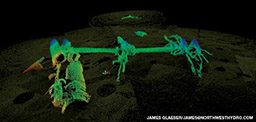
Delgado secured mission funding from the Edward E. and Marie L. Matthews Foundation and ExploreOcean and support from the National Marine Sanctuary Foundation. The two-day mission took place in September 2012 and employed a new kind of cutting-edge sonar technology: BlueView. James Glaeser of Northwest Hydro procured the high definition 3-D tool, the BV5000, that employed this technology to map the 220-foot-long steam-powered sidewheeler. The Flower Garden Banks National Marine Sanctuary (FGBNMS) provided the RV Manta as a platform for the mapping operation.
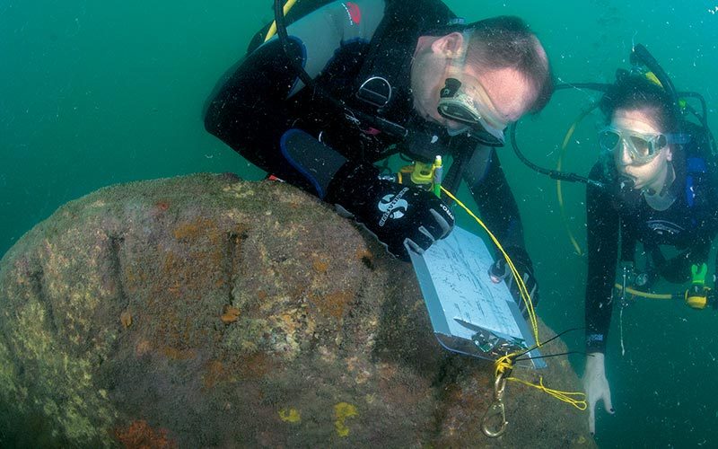
Glaeser directed the scanning operation in coordination with Emma Hickerson, research coordinator for FGBNMS, who orchestrated her dive team to reposition the tripod-mounted scanner 24 times. Prior to initiating the scanning operation, divers established the wreck’s centerlines using measuring tapes stretched from bow to stern as well as across the wreck from sidewheel to sidewheel. Thirty-five dives later, over a two-day period with visibility that ranged from 5 to 15 feet, the scans were completed. (Fortunately, visibility is not an issue with sonar.) Glaeser created maps using mosaics of the scanned images. The technology employed also allowed creation of virtual 3-D “fly-throughs” of the wreck site. This was the first-ever application of this state-of-the-art sonar technology on an archaeological expedition to a marine shipwreck.
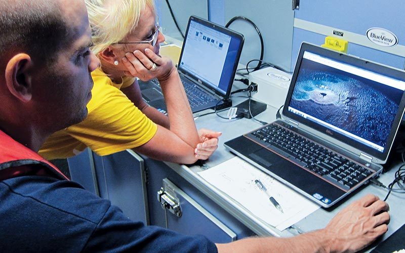
Considering the mission’s complexity and the number of factors that challenged communication and coordination along with the fact that divers were using tools they had never handled before in near-zero visibility, the results of this project were outstanding. In addition to the detailed 3-D map, new photographs were captured, and previously unobserved bow features were discovered.
Education was an important aspect of the Hatteras mission. Along with the support received from Teledyne BlueView, ExploreOcean of Seattle provided sponsorship for two local high-school students and three students from Texas A&M University at Galveston to participate. All were involved in deploying the sonar system and assisting the science team topside.
On the first day at the wreck site the mission began with a formal memorial service for the two sailors who lost their lives during the battle. A fireman and a coal heaver, both Irish immigrants, never left their stations and heroically went down with the Hatteras.
Delgado summed up the Hatteras mission when he said, “This technology [BlueView] allowed us to virtually raise the Hatteras while leaving her entombed as a war grave.” There is no doubt that the 3-D images and photographs will not only benefit archeologists and historians but also give history enthusiasts and the general public a clearer view of the fascinating maritime heritage of our Gulf coast from 150 years ago.
© Alert Diver — Q2 Spring 2013