A strong current sweeps the pinnacle known as Nine Fathom Reef, never completely dissipating as we descend the anchor line through the darkening blue water. At the top of the reef, I pause to get my bearings. The depth gauge shows 40 ft (12 m), and mindful of the plan presented to us by the captain, we immediately work forward from the anchor to avoid getting pushed out into open ocean.
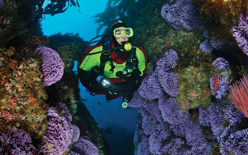
We drop down a chasm that runs to the bottom at 90 ft (27 m). The near-vertical route takes us through an overwhelming reefscape. Brown palm kelp stalks, red gorgonian fans and foot-high tufts of purple hydrocorals all provide camouflage for our approach. “Purple” doesn’t quite describe the color; each hydrocoral illuminated by my dive light exhibits a slightly different hue ranging from electric blue to deep violet. Pretty. But we’ve got an objective to achieve, and so we push on.
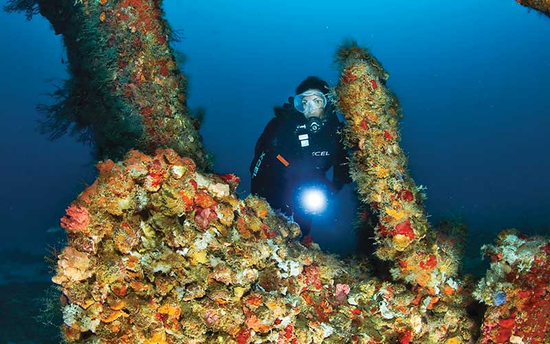
My light sweeps across the reef, and there they are! Hunkered down beneath an overgrowth of gorgonians rests a platoon of lobsters, their wary antennae now tracking my every move. My excited yelp startles my buddy to attention, and he moves in for the shot — with a camera, of course. Mission accomplished.
Military Secrets
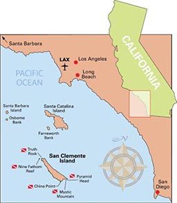
It’s hard not to think in military terms when you’re diving remote San Clemente Island, southern California’s best-kept diving secret. The 21-mile-long (34 km) island is the most southerly of the eight Channel Islands, and it’s owned by the U.S. Navy, which uses it as a combat training ground and bombing range. On your surface intervals, you can watch F-18s scream overhead or imagine what it must be like to be a SEAL scrambling ashore. But the best action is found underwater, on more than 12 dive sites that are open to civilians.
The sites are accessible only by infrequent multi-day charters, like the one we took aboard the Conception out of Santa Barbara. It’s a bit of a haul to get here, and the ever-present current can be a challenge, but the island gathers into one largely undisturbed place everything that seems rare at the other Channel Islands — pinnacles, steep walls, underwater arches and kelp-covered rock reefs, all populated by an unbelievable variety of marine life.
At Truth Rock, which rises from the bottom at 45 ft (14 m) to within 15 ft (5 m) of the surface, we anchor within view of what looks like a villa on a terrace overlooking the sea. This is no high-end beach house; Navy SEALs use this structure to stage amphibious assaults. Underwater, sheepshead abound, with females vastly outnumbering a few large males, and the combat for their attention is real. During the dive we see several female sheepshead approach each other head on, abruptly stop, bare their large mandibles, and break off, reverse course and quickly swim away.
Pyramid Head — a large, conical volcanic rock, one of several that sprout on the southeast corner of the island — is home to a quintessential kelp forest towering over a shallow reef. An outer wall steps down to a depth in excess of 100 ft (30 m), colored by yellow sponges intermixed with a variety of anemones. Ascending toward the surface, we take a kelp forest canopy tour and discover the wonders of mid-water diving. The ever-present opaleyes kiss the kelp fronds, kelp bass saunter about, and a silver sheet of bonito — one fish wide, by 50 fish deep, by several fish long — passes by like a shimmering mirage.
About a half-mile west and seaward of Pyramid Head lies Mystic Mountain, a conical shaped feature that rises from 140 ft (43 m) to about 65 ft (20 m) below the surface. The filtered light of an early summer’s morning illuminates a kinetic panorama. Large sheepshead plow the water. Blacksmiths swim through the current-loving red gorgonians. Golden seafans gently sway in time with the kelp.
Our last dive is China Point, where an extensive kelp mat shadows a series of low-profile reefs and narrow sand channels. We start the dive at about 65 ft (20 m) and head shoreward, where we find all the expected critters — lobster, garibaldi and blacksmith — in great numbers. We also spot a specimen of the really big fish this area is known for: calico bass, which turns and accelerates away from me, hugging the terrain like the fighter-bombers that buzz the terrestrial range above.
Our reconnaissance complete, we withdraw to the surface to ponder San Clemente Island’s dichotomies: isolation adjacent to a crowded coastline and peaceable diving in the midst of military operations. Diving this good is supposed to be impossible to find. Yet here it is, hiding in plain sight.
How To Dive It
San Clemente Island is owned and controlled by the U.S. Navy. Waters around the island are usually open to divers, though officials may restrict access to certain operating areas. Visit San Clemente Island for more information on closures.
Conditions: Average water temperatures are in the mid-60s°F (15°C), with lows in the low-to-mid 50s (10°C) in winter. Visibility ranges from 40-60 ft (12-18 m) in winter and spring and 60-90 ft (18-27 m) in summer and fall. San Clemente Island offers a variety of dive spots whose offshore location, deep water and variable currents combine to make for challenging intermediate to advanced diving.
Getting There: The island’s relatively remote location from the mainland means that it is not as frequently visited by charter dive boats as the other Channel Islands. Multiple-day liveaboard trips are the norm, with occasional all-day trips from the Los Angeles and San Diego areas.
Dive Operators: For more information on the Conception, which leaves from Santa Barbara, visit Truth Aquatics. For information on charters from other Southern California ports, visit California Dive Boats.
© Alert Diver — Q4 Fall 2009