In 1708 British warships sank the Spanish galleon San José, dubbed the “holy grail of shipwrecks,” near the port of Cartagena, Colombia, during the War of the Spanish Succession, killing all but 11 of its 600-person crew. The storied 62-gun, three-masted warship was thought to be carrying six years of accumulated taxes and profits — more than 200 tons of gold, silver and emeralds — collected from Spanish colonies in Latin America to help finance the king’s war effort. When the ship met its fate, it was the largest warship among a Spanish fleet sailing to Cartagena from Panama before a planned return to Spain. Its cargo is estimated to be worth as much as $20 billion, 50 times that of the famed Atocha wreck, which would make it the richest treasure ship on record. Various entities have endeavored to find the sunken galleon, especially with such a treasure presumably somewhere on the seafloor.
Uncertain Results
In 1979 the ocean salvage company Glocca Morra requested permission to explore for the San José and other valuable shipwrecks lying off the Colombian coast. Colombia’s maritime authority, Dirección General Marítima (DIMAR), in January 1980 awarded the company a license to conduct a two-year, three-phase exploration and reconnaissance operation to locate shipwrecks within a specified area. The license entitled Glocca Morra to 50 percent of any treasure that it found as per Article 701 of Colombia’s civil code but required that government officials be present to monitor every step of the operation.
In the first phase, which began in June 1980, the company spent four months surveying the area with side-scan sonar and identified dozens of potential targets from the sonar’s paper printouts. The crew and their government monitors returned in October to expand the survey area and investigate areas of interest using side-scan sonar, a continuous transmission frequency modulation (CTFM) sonar for continuous scanning, a subsoil profiler to measure sediment thickness, and an underwater remotely operated vehicle (ROV). Equipped with a TV camera, still camera and specimen basket, the ROV was maneuvered by remote control from the ship and attached with a 5,000-foot-long umbilical, making navigation imprecise. Over the next 10 months the crew identified several promising areas that contained wood debris and other man-made objects and recovered a wood sample that was determined to be at least 300 years old.
In October 1981 Glocca Morra returned with a surface vessel and the repurposed passenger submarine Auguste Picard, which formerly carried tourists to the depths of Lake Geneva in Switzerland. It had three observation windows and was equipped with side-scan sonar, CTFM sonar, a subsoil profiler, a magnetometer and an underwater TV camera to investigate potential targets. Glocca Morra also deployed a transponder system for the sub to communicate with the surface and to help determine its position underwater.
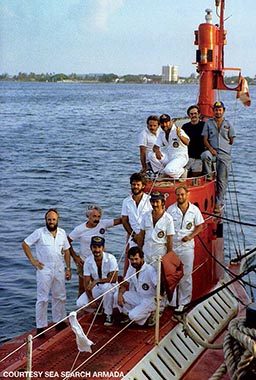
On Dec. 10, 1981, the Picard’s side-scan sonar and magnetometer recorded a major target, which was investigated on subsequent dives. The crew found several large debris fields that they believed to be the San José. “It was right where our archival researchers said it should be,” recalled Jack Harbeston, managing director of Sea Search Armada (SSA), a partnership formed by Glocca Morra and other investors in November 1981 to help finance the mission. “The sub crew could see wooden ship spars, square nails that had rusted out and a cannon.” A second wood sample confirmed the wreck was the right age.
Glocca Morra filed a report of its findings with DIMAR in February 1982; the report included a map with the approximate coordinates of the San José. Civilian long-range navigation (loran) systems or GPS, which is generally accurate to within 33 feet, were not available at that time, so the company had to use less-precise methods. The 1:80,000-scale nautical map (1 inch = 1.26 miles) was made using sextants, which are accurate to only 1 mile to 3 miles, and underwater triangulation. DIMAR subsequently acknowledged the find, and a year later the government approved the assignment of rights to Glocca Morra.
By that time the company had invested more than $6 million and was nearly out of money. In 1983 Glocca Morra transferred its rights to SSA, which raised an additional $5 million and took over management of the project.
SSA was granted permission to revisit the target along with Colombian government observers in 1983 with the hope of making a positive ID. The company shot video from the sub that showed the remains of a wooden ship approximately the size of the San José, but it was unable to make a definitive identification. Harbeston acknowledged that the evidence of the find was circumstantial, but the government would not let SSA return to the site for further verification and repeatedly denied SSA’s requests to salvage the artifacts the sub had found. SSA also filed claims on five other targets based on sonic and magnetic analysis. It was SSA’s last expedition to the site, so the San José remained officially undiscovered and the contents of its hold an enigma for 32 more years.
Finding a Needle in a Haystack
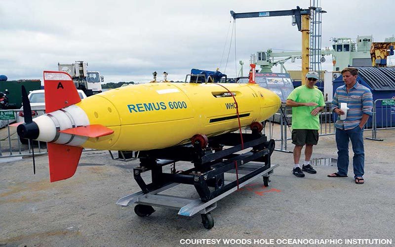
On Dec. 5, 2015, Colombian President Juan Manuel Santos announced that an international team of researchers working with his country’s Ministry of Culture had found the San José on Nov. 27, 2015. More than two years later, after having been released from a nondisclosure agreement, Woods Hole Oceanographic Institution (WHOI) revealed in May 2018 that it was responsible for finding and identifying the 300-year-old shipwreck at a depth of approximately 2,000 feet using its REMUS 6000, an autonomous underwater vehicle (AUV) designed for searching the ocean floor. The prestigious nonprofit research organization conducted the search under the direction of British firm Maritime Archaeology Consultants (MAC) and in cooperation with the Colombian government aboard a Colombian naval research vessel.
Rob Munier, WHOI vice president for marine facilities and operations, first discussed the San José project with MAC’s lead archaeologist, Roger Dooley, while attending a conference in late 2014. In early 2015 they traveled to meet with representatives of the Colombian government and inspected the proposed Navy research vessel, ARC Malpelo, as part of WHOI’s due diligence.
It was not the first time the venerable 88-year-old scientific institution had been asked to find a high-profile target. WHOI found the wreckage of Air France Flight 447 off the northeast coast of Brazil in 2011, retrieved the data recorder from the cargo ship El Faro that sank during Hurricane Joaquin in 2015 and recently participated in the searches for Amelia Earhart’s plane and the missing Argentine submarine San Juan. Their highest-profile discovery to date came in 1985, when a WHOI team — in partnership with the French oceanographic institute IFREMER — discovered the remains of the Titanic. WHOI also produced a photogrammetric map of the Titanic in 2010. The San José would be the latest in WHOI’s history of using their considerable technology and experience to conduct difficult searches.
Larry Madin, WHOI’s deputy director and vice president for research, said their criteria for third-party projects are twofold: The request must come from a responsible party with appropriate legal authority and should require WHOI’s unique capabilities represented by its AUVs and operational expertise. “We have been approached by treasure hunters over the years but never engaged,” Madin explained. WHOI agreed to take on the San José project on an at-cost basis for services, time and equipment, just as they would operate under a research grant. “We were paid the same as if we had found rocks,” he said.
Created with support from the U.S. Navy, WHOI’s REMUS 6000 is designed for autonomous long-duration mapping and surveying operations to depths of 6,000 meters (19,685 feet or 3.73 miles). The bright-yellow, torpedo-shaped vehicle — measuring almost 13 feet long and weighing close to 2,000 pounds — is equipped with a titanium pressure hull and rechargeable lithium-ion battery pack. It can travel at speeds up to 4 knots for up to 22 hours and follow the subsea terrain at a fixed depth.
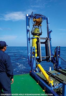
Munier described the San José search operation as “mowing the lawn.” Flying 230 feet above the seafloor at about 3 knots, REMUS uses side-scan sonar to image successive overlapping swaths of seabed. In addition to its inertial guidance system, the AUV relies on a series of deployed transponders that act like an underwater GPS to fix its position with an error of 1 meter per kilometer. At the end of an 18- to 22-hour run, the crew retrieves the vehicle and removes the hard drive, which can contain up to a half terabyte of imaging data for expert analysis. They can then send back REMUS to photograph items of interest with its high-resolution digital camera. “It can literally find a needle in a haystack,” Munier said. This search, however, would be attempting to find a very old needle in a very deep haystack.
The WHOI team spent a week and a half aboard the Malpelo in June 2015 unsuccessfully searching for the San José based on a map provided by MAC. Unfortunately, they had to discontinue the operation because the vehicle was scheduled to be elsewhere.
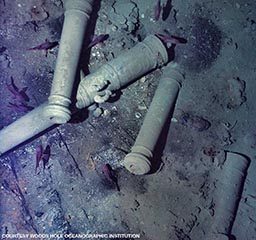
A few days after the team returned and resumed operations in November 2015, REMUS found what looked like a promising target. At that point the AUV had searched approximately 80 square nautical miles, an area slightly larger than Orlando, Florida. They redeployed REMUS to the site the next day and took high-resolution photos from about 30 feet above the wreck. A marine archaeologist was able to identify the San José from the dolphins carved on the cannons. The rest was history. “Finding the wreck wasn’t that big of a challenge,” Munier said, citing the relatively flat seafloor. “The hardest part was keeping it under wraps.”
Nearly 40 years after the first searches began, WHOI leveraged its technology and methodology to find what had eluded previous expeditions. There are still many unanswered questions about what will become of the San José; many claims of ownership have been made, and what should be done with the treasure and artifacts aboard is hotly contested. In a press conference alongside Colombian President Iván Duque Márquez in August 2018, Spain’s Prime Minister Pedro Sánchez voiced his hopes for a resolution: “The solution lies in finding a way to contribute to the intellectual enrichment, culture and history of humanity.” Although the outcome remains to be seen, delving through 300 years and nearly 2,000 feet of water to find the San José is the first step in uncovering an incredible piece of maritime history.
Explore More
| © Alert Diver — Q4 Fall 2018 |