HMCS Canada Expedition documents 1926 shipwreck
Out of a milky blue haze off Florida’s Lower Matecumbe Key, the hull of a ship emerges slowly — steel rising from sand, intact, unmistakable, and improbably complete for a ship that has been underwater for a century.
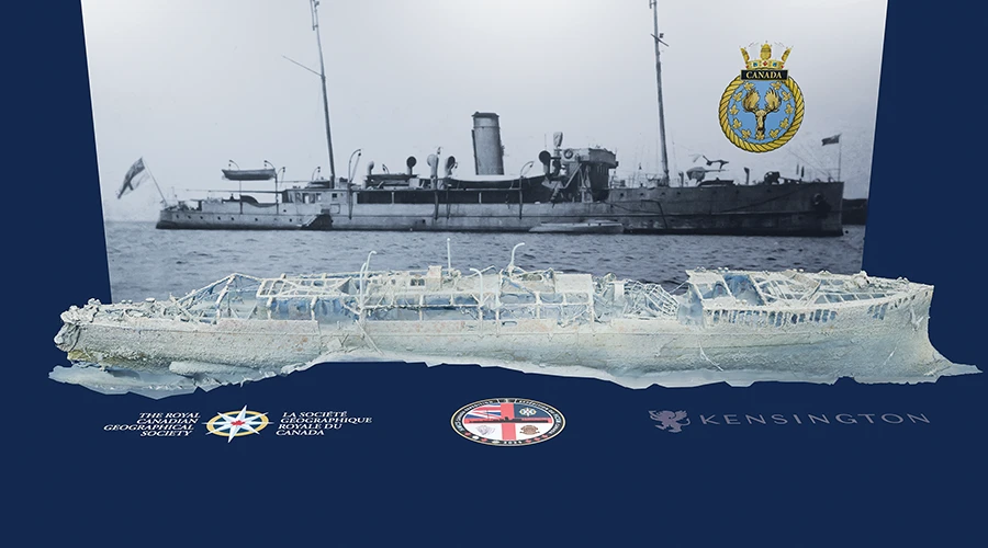
The hull lines in view, and its distinctive ram bow still cutting forward, it rests proudly at 235 feet (72 meters). This ship, the HMCS Canada, was Canada’s first purpose-built warship and has been largely forgotten back home.
Commissioned in 1904 for the Department of Marine and Fisheries, Canadian Government Ship (CGS) Canada was armed with four Mark III 1½-pounder quick-firing guns mounted on the main deck, two forward and two aft. With a complement of approximately 75 officers and men, it served on fisheries patrol duties and as a naval training vessel.
In design and capability, it closely resembled a Royal Navy armed third-class cruiser, but the Canada was unique, and its unusual characteristics led to its eventual identification by the National Oceanic and Atmospheric Administration (NOAA) in the early 2000s.
The Canada underwent major armament and seakeeping upgrades in 1912, including raising the forecastle to improve performance in heavy seas and adding larger guns. The ship was transferred to the Royal Canadian Navy (RCN) in 1915 and became His Majesty’s Canadian Ship (HMCS) Canada. Between 1915 and 1916, it received further naval artillery upgrades as part of its transition to frontline service during World War I and was armed with two 12-pounder guns forward and retained two 3-pounder guns aft.
The Canada served as a training vessel and a convoy escort, protecting merchant shipping against German submarine threats. It became the RCN’s second flagship in 1917 and, in the same year, survived the Halifax Explosion — the largest nonnuclear, human-made explosion in history. The ship was decommissioned in November 1919.
In 1924 the RCN sold HMCS Canada to American businessman Barron Gift Collier, who renamed it SS Canada and then SS Queen of Nassau. Collier refurbished the ship and dispatched it on first-class passenger service between Miami, Florida, and Nassau, Bahamas. It was unsuited to passenger service, however, and Collier sold it — one of his few business failures.
Mexican commercial interests purchased the ship in 1926 and planned to place it in service between Tampico, Mexico, and New Orleans, Louisiana. The Queen of Nassau pulled anchor in Miami in July 1926 and steamed toward Tampa, Florida, for final inspection before entering that service. Approximately 50 miles (80 kilometers) south of Miami, however, the ship’s lower compartments started to flood. After the crew battled the incoming water for an hour and a half, the captain ordered everyone to abandon ship. It sank off the Florida Keys on July 2 in what is now the Florida Keys National Marine Sanctuary (FKNMS).
NOAA first documented the wreck in the early 2000s under the direction of archaeologist Tane Casserley, who followed up on reports from technical divers who had dived the wreck. That work established baseline measurements, produced videography, and determined its identity.
In the two decades since then, however, the site has seen limited subsequent research at modern resolution, given the challenging conditions and difficulty inherent with technical diving operations beyond 200 feet (61 m).
I learned from the FKNMS office that the sanctuary’s Queen of Nassau had been the RCN’s second flagship. As a retired RCN officer, I took immediate interest in the ship. Initial plans for a commemorative dive to mark the 115th anniversary of the RCN in 2025 grew into a full-blown archaeological and ecological study of HMCS Canada.
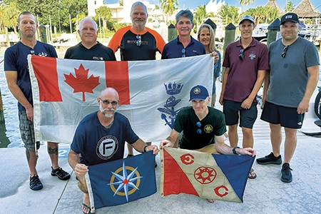
The HMCS Canada Expedition team grew along with its goals. I remained the overall expedition lead, and Guy Shockey joined as the dive lead. Roger Lacasse, PhD, brought 3D photogrammetry skills, and Ewan Anderson’s photographic and archaeological expertise rounded out those aspects. Rob DeProy, a former RCN coxswain of Fleet Dive Unit (Pacific), Global Underwater Explorers (GUE) instructor Jason Cook, and International Association of Nitrox and Technical Divers (IANTD) instructor trainer evaluator Kelvin Davidson — the only non-Canadian on the expedition — brought their considerable technical diving experience.
Our team arrived in Florida in December 2025 with a clear objective: to produce the first complete, high-resolution 3D photogrammetric documentation of the wreck. We wanted to provide NOAA with a new archaeological and ecological dataset that could support analysis, interpretation, and long-term monitoring. Our goal was to create a digital record that would allow the ship’s story to be reexamined. We also wanted everyone with an internet connection to be able to virtually dive the HMCS Canada.
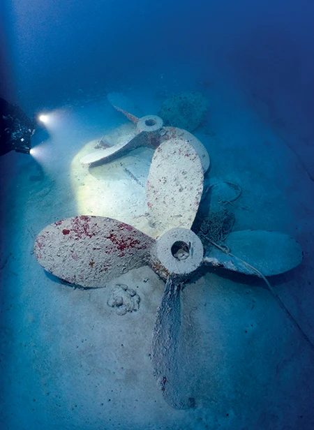
Our dive platform was Horizon Divers’ vessel Pisces, under the command of Capt. Jeff Knapp, who knows the wreck well. Knapp has logged dozens of dives on the site and described it as one of the few ships in the region at that depth that remains completely intact. He also emphasized that this wreck was a real sinking with real history, not an artificial reef, and that the difficulty of access is one reason it remains lightly visited.
The common approach to the Canada is to drift on and off, and that operational reality shaped our procedures. With three two-person dive teams, one team would be under a decompression obligation, and we made sure that Knapp never had to guess where our divers were or when they were ascending. It is not enough to be competent underwater. You must also be predictable on the surface.
Our safety and operations decisions were conservative and explicit. We planned one major working dive per team per day rather than attempting to maximize the number of dives. We agreed in advance on how ascent would work, and we those agreements were nonnegotiable.
We also prioritized keeping teams synchronized on the upline to reduce the risk of split groups drifting in different directions during decompression. Where conditions allowed, we came up together. Where conditions did not permit, we executed surface marker buoy procedures in a disciplined, standardized way.
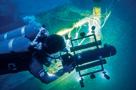
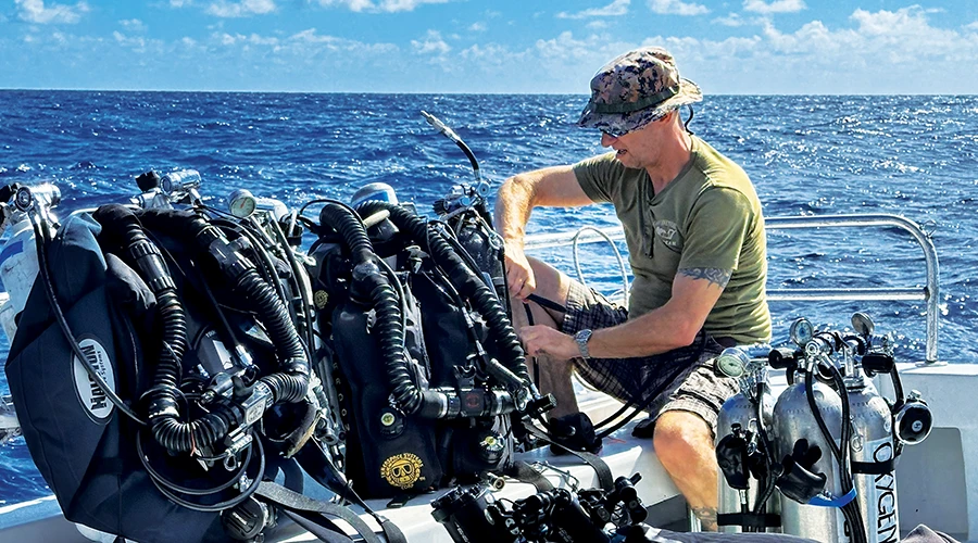
While the Canada was the historical subject of the expedition, the photogrammetry sled was the technical heart. Lacasse engineered and piloted a sled mounted on a diver propulsion vehicle (DPV) and built for efficiency and stability at depth. The system carried two GoPro 12 cameras mounted in Isotta housings and four 18,000-lumen Bigblue lights for illumination.
The choice of small action cameras was about physics, not convenience. At 235 feet (71 m), a bulky imaging rig becomes a drag problem. Drag increases workload, which increases gas consumption. Increased gas consumption shortens bottom time and increases stress. In a mission where the goal is consistent coverage and stable imagery, compactness becomes an advantage.
The sled demanded strict orientation control. It needed to remain horizontal so it did not sail in the current, and it required a consistent speed so that image overlap would be sufficient for structure-from-motion reconstruction. It also required a consistent standoff distance from the hull and enough lighting to preserve contrast, because the photogrammetry software needs sharp images to identify and match points.
We collected approximately 10,600 images over four days. The quality of those images varied with conditions in ways that any technical diver in the Keys will immediately recognize. On the first two days the suspended milky layer below roughly 187 feet (57 m) reduced contrast and washed out detail. Visibility might have been adequate for a dive, but it was not ideal for creating a precise model.
Everything changed on the third day. Surface conditions were calm, current was minimal, and visibility at depth opened to nearly 50 feet (15 m). The Canada appeared as a continuous structure rather than isolated fragments, and that day’s dives produced the most useful imaging runs. The fourth day fell somewhere in between, with workable visibility and reduced ambient light. Ultimately, we used imagery from all four days to create the 3D model.
The underwater work was methodical rather than dramatic. We were not searching for a lost wreck; we were mapping a known one. Imaging passes were structured to capture the ship in segments. Those images were then stitched together through overlap. We approached the bow castle, the deck, and the hull sides with deliberate coverage patterns. Some passes were long and straight to capture major hull surfaces. More circular passes allowed us to capture complex junctions where the deck meets hull plating, which are areas that often become critical tie points for alignment.
The HMCS Canada Expedition gave the project data to NOAA resource managers for review. Comparison of the new data with baseline records found that the wreck remains largely intact and structurally stable, but it is increasingly affected by anthropogenic — human-caused — impacts.
Lost fishing lines, nets, lobster trap ropes, and anchors are frequently snagged on the ship, breaking its structure and moving artifacts. These materials also scrape and break sponges and corals growing on the wreck, trap sediment and organic material against the steel (which speeds up corrosion), and cause ghost fishing. In short, human debris damages both the metal structure and the marine life that make the shipwreck such a compelling dive site.
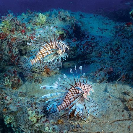
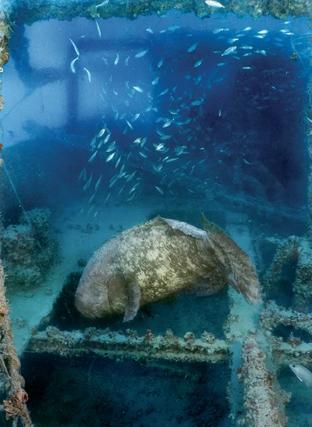
Today, the Canada functions like a layered underwater neighborhood. Its hull, decks, and passageways provide shelter and attachment surfaces for bottom-dwelling organisms — known as benthic life — including sponges, corals, algae, and shellfish. Small reef fish gather for protection, while larger predators such as goliath groupers patrol the structure.
Scientists describe this as supporting a structurally complex benthic and trophic community, meaning the wreck’s physical complexity supports an entire food web, from tiny invertebrates to top predators. This ecosystem, however, faces mounting pressure from invasive species.
Lionfish were absent during NOAA surveys in the early 2000s but are now abundant. They reproduce rapidly and have few natural predators in Florida waters, so they can significantly reduce populations of young native reef fish.
Fortunately, another invasive species, Tubastraea, commonly known as orange cup coral, was not found on the wreck. Native to the Indo-Pacific, this bright-orange coral was introduced to Atlantic waters through shipping and offshore infrastructure.
Unlike most Florida corals, which depend on sunlight, orange cup corals do not need light to survive. Scientists call it azooxanthellate, meaning it does not rely on symbiotic algae for energy. As a result, it can colonize shaded, deep, and interior portions of shipwrecks — areas where native reef-building corals struggle. If established, Tubastraea can crowd out native species and alter the surrounding reef community.
The 2025 expedition also helped resolve a long-standing historical question about the ship’s 1926 sinking. Contemporary newspaper accounts reported that as the vessel flooded and its bow rose out of the water, a boiler explosion occurred before it disappeared beneath the surface. Earlier NOAA investigations did not find clear physical evidence to confirm that dramatic detail.
During his 2025 dives, however, Lacasse observed hull fractures on both the port and starboard sides. When the 3D model was completed, it revealed cracks and outward-bent steel plates just outside the boiler room area. The direction of the damage — pushed outward from inside the vessel — is consistent with an internal steam explosion. In simple terms, modern imaging technology found physical evidence in the steel hull that supports the newspaper accounts.
The new survey also documented measurable structural change since NOAA’s last detailed monitoring in 2005. Comparison between earlier photomosaics and the 2025 3D model shows progressive deterioration of the superstructure and loss of thin steel plating around the funnel.
Particularly notable is accelerated corrosion in the ship’s forecastle — the raised bow section that had been added in 1912 to improve seaworthiness. Steel in that modified section appears to be deteriorating more rapidly than the adjacent hull plating, suggesting differences in material composition or exposure conditions. These comparisons demonstrate that while the wreck remains stable overall, it is undergoing gradual, observable changes over time.
HMCS Canada is a stable historic warship slowly evolving under modern pressures. It is a time capsule from the early 20th century and a living reef ecosystem. The most significant threats today are not catastrophic structural failure but incremental, human-caused damage and invasive species that exploit deep, less-accessible sites.
Thanks to high-resolution 3D documentation, the wreck now tells its story, both historical and ecological, with greater clarity than ever before.
To view the 3D photogrammetry rendering of the HMCS Canada shipwreck, see tinyurl.com/HMCS-Canada.
© Alert Diver – Q2 2026