Shipwrecks have always filled my imagination. When I was kid I used to pull the world maps out of our National Geographic magazines and paste them onto the ceiling so I could lie in bed, look at all the faraway places and dream of the things I could discover. At that young age, my fantasies were of ancient, treasure-filled ships in strange seas, chests of gold and piles of priceless china, all just waiting to be found by a fearless explorer.
Dreams never die easily, and a long decade later I was finally able to follow up on that early idea. When I did, however, it wasn’t the warm, clear sea of childhood memory I dived into. Instead, it was the cold, dark and murky water of New York City. My mentors were a dying breed of hardcore wreck explorers who followed that basic human impulse to peer into the darkness and see what is there. They didn’t dream of adventure, they lived it. They touched history, brought it to life and imbued a young 17-year-old with a yearning to explore shipwrecks of all ages, sorts and sizes all around the world.
I didn’t just want to explore, I wanted to learn more about the thousands of ships that disappeared without a trace, to learn their secrets and do my part in bringing the sometimes valiant, sometimes horrifying and always human stories to the world of the dry and living. But I quickly realized that telling stories of ships that were lost is difficult, because, well, the ships were lost. So before I could realize any part of my new ambition, I had one small thing to do: I had to find a shipwreck.
Looking for lost ships is not a new endeavor; as long as ships have been lost people have been searching for them. Some look for wrecks to recover lost property (insurance companies and owners), while others seek rewards for finding the lost property (salvors and wreckers). Some are just looking for loot (treasure hunters), while archaeologists search for wrecks to learn from the past. There are likely as many reasons to look for lost ships as there are ships on the bottom, but the many disparate groups who look are bound by one common feature: the unbelievably costly, time-consuming, tedious and frequently unrewarding nature of the search.
Searching can be absolutely maddening. You know the wreck is there. It’s nearby. You can feel it in your bones. The historical record tells you it’s there. Your instinct is to just go to a spot and look, and then go to the next spot where you think it is and look there. Nothing. Try again over here. Nothing. Try again over there — and you do this repeatedly until you realize you have absolutely no idea where the wreck is. What’s worse, you have no real idea of where you have already looked. At this point you either give up, or you get serious.
Getting Serious
If I were to teach a course about “getting serious” when looking for wrecks, I would put one word on the board, and we would spend the first three weeks just sitting in the room and not saying a word. No reading, no texting, nothing but sitting quietly, looking and thinking. At the end of the three weeks, those who were still there would have learned the first real lesson of wreck exploration: patience.
Traditionally, hunting for shipwrecks starts in the library. Professional wreck hunters such as Bob Marx, David Trotter and Bob Ballard will all tell you that research is where the search begins. They know it can take days to search what amounts to a pinpoint on a map, so the closer you can get to a ship’s last known position before you start looking, the better off you will be. Research, especially for older wrecks, can be incredibly fascinating, but you can spend weeks — even years — searching through deck logs, old letters and anything else that may contain a clue about a vessel’s last location. I have spent many hours looking for World War I and World War II wrecks, and we have found that the average ship on the bottom with known coordinates in the 1940s can be 10 miles or even farther from where it’s supposed to be. And these are navy ships with expert navigators and meticulously kept records that went down only 70 years ago. What about the wrecks that are 500 or 2,500 years old? Fortunately, we live in an age where technology is ubiquitous, and many brilliant people have created tools for scouring the bottom of the ocean.
Leveraging Technology
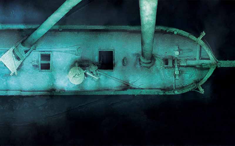
In 1985 Bob Ballard found the most famous shipwreck in the world — the RMS Titanic. During the third search trip for the Titanic, after a week of poring over the bottom of the Atlantic, it was located using a towed camera array nicknamed Argo. That particular trip was funded in part by the Office of Naval Research (ONR) and run by Woods Hole Oceanographic Institution. It was a joint effort to hone skills using the Argo platform in deep-ocean survey work. Argo would go on to find the Bismarck just four years later in more than 15,000 feet of water.
Some consider the technology primitive by modern standards; it consists of a camera, attached to the end of a cable, that displays a 50-foot section of the bottom at a time and requires someone to watch it 24/7 for weeks on end. (Patience, anyone?) To put it in perspective, if you wanted to search a 1-mile by 1-mile box traveling at about 1 mile per hour (typical survey speed) with full optical coverage, it would take about 60 hours, and that doesn’t even account for turning the ship around. When searching from a large ship, the lanes are typically much longer than a mile since it takes so long to turn the ship around, especially when there are several miles of cable behind it. When searching for the Titanic, the researchers were not looking for full optical coverage though; they were looking for a debris trail, so they left nearly 1 mile in between each of their 5- to 8-mile-long lanes. Searching in the deep ocean has never been easy, but technology has made some aspects of it very different. Other aspects remain tediously familiar.
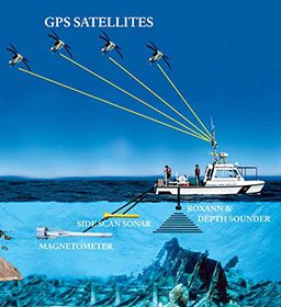
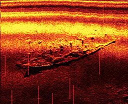
Deep shipwreck hunts are expensive. A ship can cost $15,000 to $60,000 a day, depending on the capabilities desired, and it’s just the platform from which the search is launched. Finding ways to maximize time on the bottom is imperative; fortunately many technologies facilitate just that. Like Argo, side-scan sonar is towed behind a ship at a designated altitude off the bottom; it emits sound waves to create an acoustic image of what’s around it. Since sound waves travel so efficiently underwater, side-scan can provide a picture of the seafloor several hundred meters to either side of the unit, a much wider swath than the camera sleds of years past.
Side-scan is reasonably priced (models range from $12,000 to $100,000), and it has become the principal tool used by most wreck hunters around the world. Side-scan’s versatility is hard to beat: The units are small, they’re useful for both deep and shallow exploration, and they offer relatively wide bottom coverage. Multibeam sonar is a variation of side-scan that emits multiple sound waves and creates a three-dimensional image of the bottom. It is often hull mounted but is sometimes towed, and it is significantly more expensive than side-scan.
The next generation of side-scan is called synthetic aperture sonar (SAS), and it makes traditional side-scan look like an old standard-definition TV relative to a new HD model. While side-scan emits one sound pulse followed by another, SAS emits many sound pulses and then uses sophisticated processing techniques to interpret and display them as an image. At first glance, the image from SAS looks almost identical to side-scan, but then you realize the image from a single lane is nearly two miles wide. Not only is it so wide, but even at the very edges of the lane the resolution is capable of showing the propeller of a small airplane and allowing the viewer to count the blades. Although the swaths are not quite as wide in shallower water, the resolution is still substantially higher than in traditional side-scan.
To cover a wide swath of seafloor with side-scan, you would start by using low frequency to scan a large area. If you found a target you would make another pass with a narrower swath but a higher frequency, creating a much higher-resolution image. With SAS, only one pass would be made, and the resolution would be just as good if not better than the highest-resolution side-scan image, all while covering hundreds of times more bottom than the side-scan. The downside of SAS is cost and size; even for a shallow-water version I was recently quoted $160,000 for a 10-day search. That’s unaffordable for most people (including me), but for institutions and those with deep pockets, SAS is an incredibly useful tool — especially if it can be combined with other search tools.
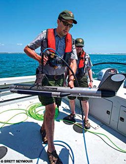
A magnetometer is similar to a compass in that it detects the earth’s magnetic field, but a “mag” is infinitely more sensitive. As with many search tools, a mag is towed behind a boat while an operator watches a screen for variations in the magnetic field. As the fluctuations get stronger, the operator can follow the anomaly and identify it using sonar, side-scan or some other device capable of “seeing” the bottom.
An interesting question might arise if you come to an area with a magnetic anomaly but without any visible sonar evidence. This is where sub-bottom profilers may be very useful. Designed to characterize layers of sediments sometimes hundreds or thousands of feet down, these tools are, at least in theory, incredibly handy when searching for buried shipwrecks. Unfortunately, they have not yet lived up to the hype, but there is still hope that sub-bottom profilers one day will provide detailed images of wrecks that lie beneath the sediment.
Another instrument commonly used by wreck hunters is a fish finder. Fish finders emit and detect reflected sound waves and display a simple representation of the water column and the bottom under the boat. Fishermen use them for the obvious reason, and boaters use them to ensure there is enough water beneath the keel. Dive operators often watch the fish finder for the bump on the bottom that signifies a wreck, and crews of wreck hunters often keep a pair of eyes glued to the fish finder as they “mow the lawn,” searching the ocean floor.
Mags, side-scan and fish finders have been the principal tools used to find almost all shipwrecks that have been discovered. The common factor in all these tools is the human interface. From running boats to watching cables to putting eyes on the screen, human control has been the connective tissue that allows all these technologies to work. However, like the rest of society, ocean exploration is undergoing a quantum leap in technology, and the way we find wrecks is beginning to change. This change is largely being fueled by the use of robotics, especially autonomous underwater vehicles (AUVs).
AUVs
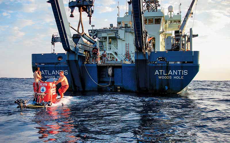
AUVs represent a great technological leap forward in ocean exploration and shipwreck hunting. They have been in development since the 1960s but have only recently, with the creation of remote environmental monitoring units (REMUS) at Woods Hole, come to the forefront of exploration. REMUS vehicles look like torpedoes, but instead of carrying explosives these AUVs carry various arrays of remote-sensing tools (side-scan, multibeam, sub-bottom profilers and more) along with cameras and lights. An AUV is programmed for a mission and then deployed off the stern, which leaves researchers on the ship free to perform other tasks. While on its mission, an AUV uses internal sensors and sonars to avoid objects and follow the contours of the bottom.
Such capabilities are very exciting for those whose searches take place in areas with canyons or extensive coral formations. Side-scan and other towed sensors can be stymied by high-relief bottom topography, but REMUS vehicles are able to get inside these difficult areas, making searching them incredibly more efficient. REMUS AUVs have already mapped miles of ocean around the Titanic, found a lost Air France plane off Brazil and found countless shipwrecks across the world. Although AUVs can search the bottom based on preprogrammed missions, data still must be downloaded and interpreted when the units surface. Depending on the data, this may take hours, days or even months. Humans are not out of the game quite yet.
Archaeologist Brendan Foley uses AUVs to help find shipwrecks and shed light on ancient trading practices. Foley is part of the upcoming generation of maritime archaeologists that embraces the use of technology in the search for lost shipwrecks. Not only has he successfully used AUVs in his hunt for Minoan shipwrecks in Greece, he is also one of the few in the archaeological community using closed-circuit rebreathers for exploration.
The Future of Exploration
Today we are experiencing something of a renaissance in the world of science and exploration. Most of us are used to seeing the government fund or encourage many of the technologies used for research expeditions. However, as government coffers run dry, agencies such as the National Science Foundation (NSF) and the National Oceanic and Atmospheric Administration (NOAA) are cutting back on what they are able to spend to fund these projects.
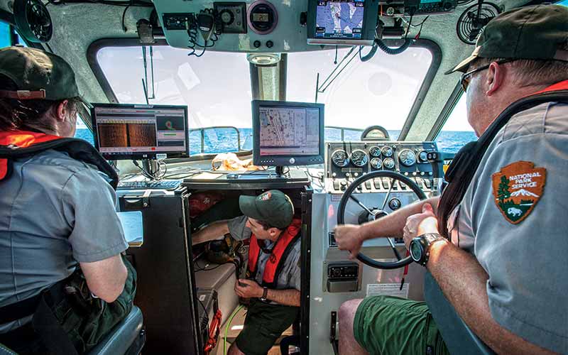
Harkening back to the days of Michelangelo, when well-off patrons subsidized many of the world’s greatest artists, a portion of the world’s wealthiest people have taken a profound interest in ocean exploration and shipwrecks they believe to be culturally significant. Across the world, there is now a fleet of “research yachts” that carry equipment such as submarines and AUVs with advanced scientific and imaging capabilities. Many of these new patrons to science and archaeology are beginning to fund expeditions that, at least in part, involve shipwreck hunting. Although the government is not funding these endeavors to the extent it once was, governmental agencies including NOAA and the National Park Service (NPS) continue to document what exists along our coasts and in our lakes and rivers.
As technology gets better and cheaper, it’s easy to imagine a future in which a fleet of robots scours the ocean floor, creating a map of literally everything both above and below the sea bed. There are already designs for massive hubs that would allow scores of AUVs to download information, charge batteries and keep humming along the bottom in their relentless search of the sea. That is the future, however, and for now humans still have a tremendous impact on how wrecks are found. The great majority of known wrecks that lie within dive depths were found by divers or fisherman using nothing more than a fish finder. In fact, if it lies within dive depths, it’s probably covered with nets and fishing line. Every new wreck we have found over the years has been.
Technology enables us to do tremendous things, but even with all the funding that is still available and all the robots in the world, it is the private individual who will find the wrecks that lie in our own back yard. Even as I write this, a submarine I have spent three years searching for was just found by another group of technical divers. They also spent countless hours looking over charts, reading old deck logs and towing a cable over more than 100 miles of endless sand dunes, learning and relearning the value of patience. But this time instead of pulling up the cable and making the long trip home with only lines on a chart to tell them where the sub was not, their patience paid off, and they located the U-550, a submarine with its own incredible story. But that story is theirs now and no longer mine to tell. With their find they have reminded me of that earliest lesson, patience. And now, at last, we come to the next great lesson in wreck hunting: persistence.
© Alert Diver — Q4 Fall 2012